Insight
What does BIM mean to Landscape Architecture?
26 Apr 2022
Although Building Information Modelling (BIM) is no longer a fresh new concept in the construction industry, sometimes it can still be a bit intimidating to Landscape Architects or landscape practices that have not engaged with it yet - from a previous survey, Landscape professionals were very under-represented among respondents (Landscape Institute, 2017 https://www.landscapeinstitute.org/news/nbs-bim-2017-landscape/). The concept of BIM can sometimes be misinterpreted as the design output or the software, which has largely contributed to the confusion. BIM in fact is a working approach that puts collaboration at the core. It promotes coordination and enhances accuracy. From this perspective, BIM is not a new technology except that BIM introduced industry-wide collective common data standards and data management protocols which regulate the working process throughout the lifecycle of projects significantly improve the working efficiency.
Why was it important for our team to get involved?
The benefits of incorporating BIM are apparent. Firstly, it is needless to reinstate the importance of continuous collaboration amongst the design team. Missing BIM could leave a huge blind spot.
The Landscape profession is a discipline that is as diverse and dynamic as the landscapes they work on (Landscape Institute, 2022 https://www.landscapeinstitute.org/about/about-the-landscape-institute/). The breadth of knowledge that helps the development of effective design solutions and the various tasks that Landscape Architects can take on across the project has made it a unique profession. However, to some extent, landscape architecture has been left behind in the fast-moving evolution and sometimes can be forgotten about in the important BIM-relevant discussions. It was only in recent years, the situation started to change. (Millar, 2021 https://www.bimacademy.global/insights/digital-technologies/bim-and-landscape-architecture/). With the slow progress for the profession being seen, without a doubt, getting involved and being BIM compliant not only opens the door to broader opportunities but also, most importantly, secures our Landscape team a proactive position in the design development of a project.
What were the barriers?
Our pathway to the BIM world started from one of the MoJ multi-disciplinary commissions, HMP Glen Parva which Pick Everard was delivering with Lendlease. As is the case for other ‘newcomers’ , BIM did sound like a ‘beast’ to our team initially. Our worries came down to an extensive list of questions such as ‘What are the changes we need to make to our existing workflow?’, ‘What does the output look like?’ and ‘How much time do we need to dedicate to this commitment?’.
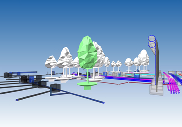
There was also a dilemma around creating 3D geometries of objects that are experiencing more changes with time such as trees (comparing to static objects such as buildings and structures). The fourth dimension that endows landscape with uniqueness also causes a literal barrier. The visual of the 3D geometry only places the living objects on a single point of the timeline, leaving us a hard decision to make - which point of time? For the purpose of clash detection, especially for MoJ projects where security standards are highest, the geometries should embed the evolving aspects of the living objects and represent the reality in a way that allows the wide design team to undertake an informative review. Unfortunately, there is not an available professional tool that enables the fourth dimension without creating an unmanageable amount of data.
How did we address the issues?
Carrying these questions, we went on a journey of experiment with a helping hand from our in-house BIM Manager. After a few rounds of trial and error, we managed to make a firm positive step. Although some particularly useful resources are also available, such as ‘BIM for Landscape’ by Landscape Institute, 2016, it was an interesting fact to realise that building data assets is a developing process that runs in parallel with the project development and therefore providing the data by stages set out in the BIM Execution Plan (BEP) and Asset Information Requirement (AIR) becomes a less overwhelming task.
Talking to the BIM Manager was the most successful approach. A few trial sessions were arranged focusing on different types of landscape objects; for instance, in terms of tree modelling, we managed to agree on the size of the 3D geometry and the inclusion of root zone and tree pit at the outset of the project. It came from our previous experience that the root zone was often left behind by other designers during the coordination whilst the roots do need space to grow without interrupting other underground services.
It is worth noting that BIM is different from creating models for visualisation although there could be some overlapping areas of the two. We arranged a series of training with our software distributor to be able to understand the capabilities, which however did not turn out as expected in the end due to the trainer having rich knowledge in model visualisation but lacking hands-on experience in BIM.
What is next?
We are proud to say that we are BIM compliant, yet the exploration has not and should not come to an end since the nature of BIM is dynamic and evolutive. We are having regular training and mini sessions so the team can stay up to date with the new tools and innovations. With the Landscape Institute’s announcement of its formal affiliation with the UK BIM Alliance last year (Landscape Institute, 2021 https://www.landscapeinstitute.org/news/uk-bim-alliance-iso-19650-revised-guidance-2021/), we are expecting to see more landscape engagement in BIM standards and guidance and most importantly how much further the BIM process can push for better collaboration.